QGIS

Description

QGIS is a free and open-source cross-platform desktop geographic information system application that supports viewing, editing, and analysis of geospatial data.

Website


How I use?

I use QGIS a lot for map creation, spatial analysis. I also give training about it and created an online course about it.

Past Projects

Health Facilities Data Collection

February 2017

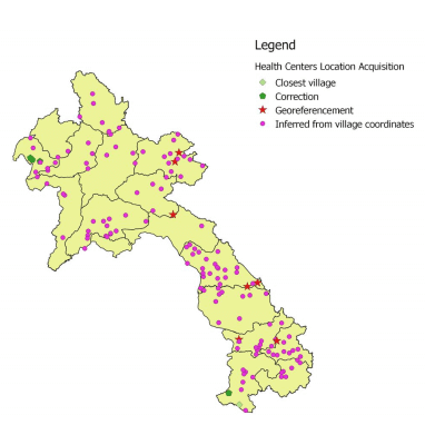
Geographic coordinates estimation for 152 Health Facilities in Laos for the Research Center against Malaria.

More...

Custom maps

Custom maps and geo-visualization for researchers.

More...

Master of Data

* IRD: Institut de Recherche pour le développement: 5-day training * LOMWRU: : Mahidol Oxford Tropical Medicine Research Unit: 1-day R training

Training on data analysis for researchers: good practices with data, map creation, charts

More...

Land cover classification

GIZ

July 2021

Automatic classification of forest cover

More...